Monday, March 21, 2011

FLW: Pope-Leighey House

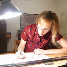
Frank Lloyd Wright's modest yet emblematic home for the young family of a newspaperman was rendered vivid for us by an amazing guide, this fellow in the bright red sweater vest.

Its preservation story is interesting and explains its current setting on the grounds of Woodlawn, an early 1800s plantation, home of George Washington's nephew and Martha Washington's granddaughter which adjoins Mount Vernon - seemingly odd neighbors for this mid-century "Usonian House, a manifesto of Wright's belief in American design for the people, unburdened by past architectural traditions."


The Pope-Leighey house was built in 1940 in Falls Church for the Pope family of middle-class means. It is easily recognizable as a cousin of Fallingwater in its natural site, materials, emphasis of compression and expansion of interior space, built-in storage for minimal possessions that is part of the architecture and many other of Wright's trademarks. The house was to be demolished in the 1960s due to the widening of a highway through Falls Church (Route 66.) The second owner of the house, Marjorie Leahey donated the house to the National Trust. A site was secured at Woodlawn, sculpted to imitate its original Falls Church site. The house was dismantled and re-built here only to be dismantled and re-built again in 1995 after it was discovered that it was sliding and sinking in the clay soil and that it was not correctly positioned in the first place. The cost was $500,000; compare that to its initial cost to build in 1940, $7,000.The house is built of natural, untreated cypress from Florida and with bricks, wood and clay of the earth. Operable glazing fit to the corners visually and spatially expands the indoor living space outdoors. The horizontal wings on axis create a low profile, with roof overhangs exaggerated in some places. A banded clerestory and vertical lite pattern cut into the cypress siding further breaks the box and blurs it endges. The pattern is curious and, according to our guide, of unknown origin. (My guess is the abstracted outline of Massachusetts, with a shorter Vermont scrunched down beside.)

Sunday, March 20, 2011

The Renewal of St. Elizabeths Hospital

We could not enter the Kirkbride Building - just these glimpses through the front entry - but photographs by Ethan McElroy capture its pallid spirit. The GSA is documenting each room prior to renovation with HABS format photographs, we learned during an extremely interesting tour by DC Preservation League, with GSA and a Project Architect.


The Government Hospital for the Insane was instituted on this bucolic site in 1855 with the completion of this, the main building and stellar example of the popular Kirkbride plan designed by Thomas Walter, then architect of the Capital. Founded by mental health reformer Dorothea Dix, the hospital aimed to provide the "most human care and enlightened curative treatment of the insane of the Army, Navy and District of Columbia." In the mid-1800s the architecture of this approach called for individual rooms, dorm-style. The campus grew with the times, adding cottages and communal living quarters, eventually housing about 8,000 patients and 4,000 staff over 300 acres by 1940. Civil War soldiers treated here referred to it as St Elizabeths, the name of the area rather than the more ominous official name of the facility and the name was changed by Congress to St Elizabeths (no apostrophe) by 1916. Chipped concrete remains of tennis courts and walking paths that meandered among specimen trees with spectacular views back to the city. The rural life in view of the city and civilization was deemed ideal for convalescence. The still-bucolic campus is within the District boundaries, on the east side of the Anacostia River. One can look across the river, scan the landmarked skyline and imagine the residents of St Elizabeths convalescing here, taking walks, writing (like Ezra Pound who spent several years here - second story, second window left of main entrance), tending their gardens, and - perhaps less bucolic - submitting to treatment for their ills. The "excited" patients were segregated within the Kirkbride building, as were men and women, as were the races. A separate building on the western edge of campus housed the criminally insane.

A daughter of a wealthy family lived in this large house built for her, with her own staff, on the grounds a short walk from the main building. Streets or lanes named "Raintree" typify a healing by nature ethic of the institution.
The western edge is the site of the massive new Coast Guard headquarters, currently under construction. A bald eagle nests in the forest on the left and is known to fly down and watch the workers on occasion.


While St Elizabeths continues to operate as a much smaller mental health facility on the eastern portion of the campus, the western 176-acre campus was abandoned in 2003. The site is a National Historic Landmark District. The buildings were stabilized by GSA and are now beginning renovation to house the consolidated Department of Homeland Security, with about 14,000 employees. It's a massive undertaking in Preservation and Renewal and the process is documented HERE.

Monday, March 14, 2011

Venezia. Il Canal Grande La Piazza S. Marco. 1828

I've found a treasure.

A gentleman, a fellow appreciator of streetscape drawings, purchased This is Savannah Vol. 2 at the SCAD Scholarship Gala Auction. He wrote to tell me of his acquisition. He also mentioned this book which he purchased in Venice.

I could pore over it all day. The comprehensive and beautiful drawings in their lithographic detail completely overwhelm me. I especially appreciate the design of the pages, artful composition of text and drawing, all in the same language: varying strokes of the pen.

Of course, Venice is the ultimate "street"scape drawing city: from one side of the Grand Canal, one can see clearly the other with very little clutter except the passing boats which present a compelling addition to the drawing. Only...it's rather a "Canal"scape.

I would like to take you to Fairlington

Fairlington is well-documented, not only on its historical marker signs, but HERE and HERE and HERE, thanks to dedicated residents who really love this historic community.

So, I'll focus on my perceptions, as a (transitory) resident.I've been planning to write about Fairlington for a while; as is often the case with something close to home, I finally will, now that my time here is drawing to a close and I've learned a little more about this epic 1940s planned community by living here for eight months. I inhabit a small top-floor bedroom in a three-story brick townhouse. I call it the baby's room; envisioning the young families moving to the area at the onset of WWII, it's the only bedroom beside the master. It is a cozy perch from which to work, with two windows and the constant white noise of I-395. I can check the traffic in a glance while sitting at my desk. Fairlington is equidistant from Old Town Alexandria and the District. I can drive into the District in less than ten minutes, depending on traffic, and bike there in about 45 minutes via the excellent trail network that converges on Shirlington. Good restaurants abound in Shirlington, as well as my favorite local paper shop, and groceries and post offices are within a ten minute walk here and on King Street. The neighborhood has a friendly, relaxed which is nowhere more apparent than strolling above 11 lanes of highway on the Abingdon Street Bridge.
Noted architects Franzheim and Mills used high-quality materials, employed architetural variety and got the traditional details right.
Two schools, a fire station, and a church in matching neo-colonial red brick and white trim round out the 3500 dwellings in the Fairlington community.
Fairlington's homes, in almost thirty different varieties, are built on the hills, on either side of 395. The high-density mixed-use development at Shirlington is in the distance, across 395 (photo above). The architects took advantage of the topography to maximize capacity and dwelling entrances. Take your eyes from the house at right (above) to house at right (below, same house) It's a two-story duplex townhouse. Walk down the steps to the left and another dwelling occupies the basement. A duplex cottage is attached at the rear. Below the cottage, another entrance from the side. That's one building, about six units. But it does not look like a typical 6-unit apartment building at all.Traditional townhouses moulded to the landscape. It is seldom that the front door actually fronts the street to which it is addressed which makes for interesting directions when inviting friends over to your house. My door fronts a lovely wooded path (above)

I would not have been inclined to choose a home that did not have a proper street address or a neighborhood whose street network was so circuitous and "suburban." But my first impression was lots of big leafy trees and well-designed dwellings. I've enjoyed calling Fairlington home for the curiosity of its era, 1940s wartime, as well as it location. The whir of helicopters so common over Fairlington is a result of its proximity to the Pentagon and a reminder of its origins as WWII Defense Housing.
Enjoy the "Reminiscences" of older folks who called Fairlington home throughout the decades.

Friday, March 11, 2011

I would like to take you to Parkfairfax

Parkfairfax was built in the early 1940s by the MetLife Corporation. Like adjacent Fairlington which was built on the mandate of President FDR by the Defense Homes Corporation, Parkfairfax housed workers and families coming to the capital region at the onset of World War II. Richard Nixon and Gerald Ford lived here while serving in Congress, but they were too late to presidency to get a Parkfairfax floor plan named after them.
I stumbled upon it as a runner and cyclist, looking to explore the neighborhood I'd recently elected to live in. It took months to understand the street patterns. I am still perplexed about the architectural patterns but pleasantly amused. Eclecticism is much more interesting than rationalism. Here are my thoughts as I roamed the neighborhood...
The {Southern Vernacular} Dogtrot meets Colonial Williamsburg

...Meets 1930s elements of Modernism

Here is what happens when you shove all those stylistic forces together, literally. As its name is a conglomeration of "park" (used throughout MetLife's portfolio of projects: Parkchester in the Bronx, Parkmerced in San Francisco) and "fairfax" (the area was part of Fairfax County in the 1800s), the buildings are architectural conglomerations.

The front facades are decorated: engaged pilasters, shallow columned porticoes, roof vent, cupola, shutters and other applied deco.
Small windows don't line up with the doors, like a child's abstract drawing of a house: doors and windows all thrown together loosely within the boundary of a roof and walls. What are they like, inside?

Where are the windows?

I found them - on the back, opting for private views over the street view.

But this one was lost on me: "front" facade on left faces a steep hillside while the "rear", windowed facade faces the street. The front doors are accessible from the parking lot by a sidewalk winding up the side of the building, cut into the hillside. This is the rule on Gunston Road, cutting through the center of Parkfairfax. "Rear" facades face the street. I imagined the "front" facade addressed another street. Nope.

Consistent colonial-inspired signage unifies the neighborhood and likely helps lost visitors find addresses. most of which do not front the street. Curious, indeed.