skip to main |
skip to sidebar
I would like to take you to the County Records
 I discovered a secret (to me) repository of old Savannah maps today. Past the offensive facade of the County Courthouse, through the automatic sliding doors with a no knives allowed sign, through the x-ray security screening, paying no mind to the large sign that points the wrong direction to the RECORDS room, around the corner by the Recorder's Court where I infamously appeared several years ago to face charges of "biking through a square," elevator to the third floor, ignoring more confusing signage, and through the unmarked door (also known as 314) to the Deeds and Records Room. Here you will find a series of huge wall maps, framed under glass, hanging on the walls. They are worn, some so much that the print is worn off. How many fingers crawled across this surface? The maps range from 1906 to about the 1950s.


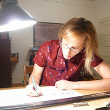
 As you can see from the photos, it is nearly impossible to photograph these maps thanks to the reflective glass, low light, and the fact that one can only view them from a distance of three feet or less. This is a room filled with shelves full of deeds, after all, not a museum. Upon asking, I was informed that the maps have not been scanned. Too bad. So - you'll have to go see for yourself.

 I discovered a secret (to me) repository of old Savannah maps today. Past the offensive facade of the County Courthouse, through the automatic sliding doors with a no knives allowed sign, through the x-ray security screening, paying no mind to the large sign that points the wrong direction to the RECORDS room, around the corner by the Recorder's Court where I infamously appeared several years ago to face charges of "biking through a square," elevator to the third floor, ignoring more confusing signage, and through the unmarked door (also known as 314) to the Deeds and Records Room. Here you will find a series of huge wall maps, framed under glass, hanging on the walls. They are worn, some so much that the print is worn off. How many fingers crawled across this surface? The maps range from 1906 to about the 1950s.


No comments:
Post a Comment