
 |
| This was the inspiration. Eastport is the northernmost port on the east coast of the United States. A history of shipping, shipbuilding, packing and canning made this town in the 19th and early 20th centuries. Its preservation and revitalization as an arts and culture point as well as a growing port again is being catalyzed in the 21st century. As part of this movement, I was hired by the Tides Institute & Museum of Art to celebrate the town in an historic mode of representation - and, as it turns out, using a modern technology. |
 |
| This is how the Bird's-Eye-View Drawing began. I cobbled together three different aerial photographs of Eastport, carefully, to ensure the drawing would include specific areas and landmarks. This is not how they made Bird's Eye Views in the 19th century! |
.jpg) |
| A large sheet of tracing paper served as my drawing surface, allowing me to see through to the aerial underlay. I began by drawing the visible streets, using a streets & lots map to infer the portions not visible. This was much more difficult than it may seem, due to the inherent distortion of the photograph. Back and forth between the Museum and me, and in the summer of 2012 I completed the Streets of Eastport and began experimenting with how best to draw the architecture. |
 |
| During the summer of 2013, I drew in pencil all the building visible in the aerial underlay. Over half were obscured by trees. Sometimes, I kind of guessed. |
 |
| At the end of the summer, I compared my drawing to a tax map with building footprints and marked, in red, all of the buildings missing in the drawing. Yikes! Some of these were no longer standing, but most were. I waited for further images - or a trip to Eastport. |
 |
| The impetus to begin again in March 2014 was a batch of aerial photographs sent by the client to help me fill in the many missing buildings. |
 |
| A stunning surprise was that Google has canvassed the town the preceding autumn and Street View was now available for Eastport! I could compare my aerial underlay with Street View images for greater detail and to see the missing buildings shrouded by trees in the aerial underlay. |
 |
| The dynamic duo of Kestrel's Aerial Photographs and Google Street View allowed me to walk down the streets of Eastport, virtually, drawing the buildings in perspective as I went. Filling in the many missing buildings, correcting the buildings penciled in last summer. The Aerials provided a great overall context. Sometimes buildings were obscured in Street View and the Aerials were essential for facade details, as well. |
 |
| And so I drew, block by block, street by street. |
 |
| I really loved seeing Eastport close-up via Street View and started a habit of making screen shots when I saw a view I really liked! Taking screen shots like snapshots as I virtually walked the streets of Eastport. |
 |
 |
 |
| I picked out a few houses I liked...noticing a definite Maine [Eastport] vernacular. |
 |
 |
| I didn't realize how many I took! It's just such a beautiful place, lovely time of year. |
 |
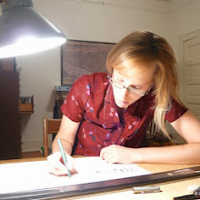
| Sometimes, the building I'd drawn in my pencil Draft was not in the right spot, or too large to accommodate the new buildings I was finding and drawing. So, I came in with my scissors or x-acto knife for drawing surgery - a trick I learned at Sottile & Sottile. I cut out the mistake, tape a clean piece of paper beneath the hole and re-draw the building. |
 |
| BEFORE AFTER More than occasionally, I realized the scale was off. The buildings I'd just drawn were too small or too large. This is more art than science. |
 |
| I ended up with many tiny off-scale buildings floating around my drawing table. They are still turning up between the floor boards. |
 |
| The South End of Moose Island, just beyond the central core of Eastport was totally obscured in the composite aerial underlay. So, this neighborhood was drawn fresh from the digital images. |
 |
| A little under half of the buildings in the town core were visible in the underlay. In pen, I added a little more detail, as well as drew their neighboring buildings. The town core is the center of the drawing, with the Tides Institute & Museum of Art (just left of my finger) and the facades of Water Street prominently visible. |
 |
| The receding view makes the land beyond Eastport appear completely forested. Drawing trees was sometimes a relief from drawing buildings in perspective. Until the end....when I had over 600 to draw. |
 |
| The northern portion of Eastport was also sparsely seen in the underlay. In addition to many houses and trees, I drew the Hillside Cemetery. The new welcome center to be constructed and the pier extension were also included. |
 |
| Finally, after two years, the delicate drawing on over thirty pieces of tracing paper and tape amounting to an area of 30" x 60", was scanned in a large roll scanner. This is a DRAFT. You'll see my pencil sketch lines still embedded. There are a few facades that still are not visible from the aerials or street views. But it sure is neat to see the island town come to life in all those ink lines! Here are some closer views of the three distinct areas within this Bird's-Eye View of Eastport. |
 |
 |
 |


4 comments:
I approve, That will be all.
I approve. A that will be all.
I LOVE your work!! I wish I could draw like that. Your art is amazing!!
oh, this is gorgeous. thank you for explaining the process, which is also gorgeous.
Post a Comment